Best Bike Paths in Northern Virginia: The W&OD Trail
Spring in the DC area lasts about as long as the blink of an eye, quickly turning hot and humid – the weather locals hate but have become accustomed to. This type of weather definitely makes exercising outdoors a bit of a struggle at times.
When the weather is mild, one of my favorite ways to get exercise is to go for a bike ride with my boyfriend. Yesterday, we went for a ride despite the temperature being in the high 80s and the forecast calling for rain on and off throughout the day. We decided to chance getting caught in the rain in order to get some exercise, so we drove from Tysons Corner to Leesburg where we access the W&OD Trail.
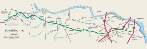
Originally, the W&OD was a railroad track. The railroad closed in 1968. In 1974, the first part of the trail opened in Falls Church and eventually, the trail evolved into what it is today: a 45-mile paved path running from the Shirlington area of Alexandria, VA to Purcellville, VA.
Our rides are typically around 20 miles (+/-) round-trip.
We’ve ridden on several portions of the W&OD Trail:
- Vienna to Dulles Town Center and back;
- Dulles Town Center to Old Town Leesburg and back; and
- Old Town Leesburg to Purcellville and back.
My favorite ride is the Old Town Leesburg to Purcellville stretch for several reasons:
- This span of the trail is very quiet and scenic
- It is the most rural part of the trail that I’ve been on
- Most of the trail is covered by trees, offering some protection from the sun or the rain
- There are beautiful homes and farms along the way
- It’s less dangerous than the Vienna to Dulles Town Center ride, since there aren’t a lot of busy roads to cross
When we go on this ride, we park in Old Town Leesburg on Church Street SE (just past Tuscarora Mill) or South Street SE. We “put in” (fancy cyclist talk for “enter” or “get on”) the trail from Harrison Street SE at mile 34.3. The 10.5 mile ride to Purcellville usually takes us about an hour riding at an average pace.
The best part of this section of the W&OD Trail (in my opinion), is that its uphill on the way to Purcellville (the inclines are pretty slight but consistent*). This means that its downhill on the way back! The decline on the ride back allows for a lot of coasting – a welcome treat 🙂
On any given ride, we see hikers, joggers, skaters, people walking their dogs, and even horses (Did you know that according to trail rules, horses have the right-of-way before people? So weird!). And we always see a lot of other cyclists.
If you like “getting back to nature,” this route is for you. Yesterday, we saw 3 deer, a turtle, and a rabbit. We also saw several different types of flowers and bushes full of almost-ripe berries. There are also some sights I look forward to such as the rustic old barn, the house up on the hill, the horse farms, and the stone bridge.
One of my favorite parts of this ride is Magnolias at the Mill, a restaurant in Purcellville. Its right at the end of the trail and we usually eat there to reward ourselves for making the 10.5 mile ride. The food is consistently delicious, the staff is friendly, and the atmosphere is casual and relaxing. Also, they are used to cyclists so dining there in cycling clothes or casual attire is fine.
The restaurant is an old, restored mill with a rustic decor that I absolutely love. The bar inside offers a full menu as well as an extensive beer and wine selection. There are various dining areas inside; there is an outdoor patio as well, which is a great place to recover from the ride while having the bike rack in view. (My favorite menu items so far include the burgers – SO good!, the soups, the sirloin skewers, and the pizza).
Today was slightly different, though. Instead of our usual meal at Magnolias, we at ate lunch before our ride at Tuscarora Mill, Magnolias’ sister restaurant in Leesburg. We weren’t very hungry when we got to Purcellville, so we rode to 7-Eleven for drinks and snacks, found a place to sit for a few minutes to eat and rest, then headed back. We got caught in the rain on the way and took cover briefly under some trees to wait out the storm. Since it was still fairly warm out and we were already wet, we decided to just ride in the rain. On this particular day, it was refreshing and our ride back was pleasant.
I highly recommend trying this route at least once. I bet you’ll enjoy it as much as I do and go back again and again!
Top Tips From A Traveling Broad – Tips & Information to Help You Have the Best Ride:
Before you begin your ride:
- Make sure you eat something. Just like you need to fuel a car, you need to fuel your body prior to exercising.
- Use the restroom. There aren’t a lot of places along the route to go to the bathroom, so be sure to “go” before you go!
- Be prepared. Make sure you have plenty of water; an extra innertube (if possible) in case of a flat; antibacterial gel; toilet paper (for a variety of uses, including the obvious); snacks; an iPod (if you’re like me & need something to distract you when you get tired); a small bag to carry the above items in (a drawstring backpack or handlebar bag should suffice).
- Dress appropriately for the weather. Bring sunglasses for bright, sunny weather; sunscreen; a hat to cover your eyes and head; a light jacket for evenings when the temperature may drop (it gets even cooler when you are moving on your bike!)
- Have fun and enjoy the ride! As I mentioned before, the scenery is really nice, so take it in as you ride.
Route Features You Should Know About:
- 7-Eleven – Down Dry Mill Road to the right (in Leesburg)
- Clarks Gap Passenger Shelter, Paeonian Springs – mile 39.2 (covered shelter)
- Hamilton W&OD Passenger Station – mile 40.9 (porta potties)
- Purcellville Train Station/End of Trail – mile 44.8 (your ride is halfway done – High Five!)
- Trails End Cycling Company – mile 44.8 (full-service bike shop; restroom)
- Magnolias at the Mill – mile 44.8 (great food; restroom)
- 7-Eleven – 700 E. Main Street, Purcellville (snacks; drinks)
Notable Mile Markers:
- Harrison Street SE – mile 34.3
- South King Street SE – mile 34.4
- Trail Bridge over Route 7 – mile 35.5
- Stone Arch over Bike Trail at Clarks Gap (Built in 1867/1868) – mile 38.2
- Trail & VA Route 9 Bridge Over VA Route 7 at Clarks Gap – mile 38.5
- VA Route 7 Bridges Over Trail & Berlin Turnpike (VA Route 287) – mile 43.2
* The trail has one hill to go up each way: on the way TO Purcellville, the hill starts right after the old stone bridge and goes up to Dry Mill Road; on the way BACK to Leesburg, the hill begins where the trail hits Charles Town Pike and goes up to the intersection of Dry Mill Road.


Great ideas! Makes me miss NoVA!
Thanks, Kim! Yes, NoVa has a lot of offer.